Clyde Hill residenceA real feasibility study
What can a first look at a real property tell you? This Clyde Hill study brings together zoning limits, parcel maps, terrain, and the questions worth resolving before paying for plans.
Start with coverage and the corner setbacks.
A 3,213 sq ft coverage ceiling is not a guaranteed house footprint.
The base setback model leaves about 3,390 sq ft inside the yards. Coverage is the smaller numerical limit, but usable space can shrink further once the layout, upper-story angle rule, easements, trees, and site conditions are tested. No maximum living-area figure is confirmed here.
Confirm how a rebuild is treated
This existing parcel is below the base R-1 minimum lot size. Resolve its legal-lot status and applicable rebuild rules with the City first.
Test two street-facing yards
The mapped corner requires two front yards. The smaller-lot side-yard angle rule can narrow the upper part of the building.
Design for the actual terrain
About 10 ft of mapped relief is a reason to check grading, drainage, foundation levels, and access. It is not a slope measurement.
The lot’s key numbers
These are saved public-record facts and preliminary calculations. The coverage ceilings describe the total site, not spare capacity after existing buildings and paving.
About 0.246 acre. The mapped rectangle is roughly 70 × 153 ft; these are not surveyed dimensions.
King County assessor ↗Total base coverage ceiling, not remaining capacity or total living area. CHMC 17.16.080.
Clyde Hill R-1 zoning code ↗Total base ceiling. A surveyed site plan must count applicable existing and proposed surfaces. CHMC 17.16.080.
Clyde Hill R-1 zoning code ↗Measured at each point of the building. Limited exceptions and separate accessory rules apply. CHMC 17.16.020.
Clyde Hill R-1 zoning code ↗Mapped street frontage determines the two fronts. Upper portions of the building also need a side-yard angle check. CHMC 17.16.040, .050 and .070.
Clyde Hill R-1 zoning code ↗This is not unlimited floor area. Coverage, height, setbacks, site conditions, and other standards still control the design.
Clyde Hill R-1 zoning code ↗Mapped envelope only. It is neither an approved footprint nor extra capacity on top of the coverage limit.
King County parcel map ↗Three intersecting County contour records show about 10 ft of relief. A topographic survey must confirm actual grades.
King County iMap for this parcel ↗The saved study matched the assessor parcel and R-1 residential zoning. Confirm the applicable rules with the City before design.
King County assessor ↗See the lot, terrain, and setbacks.
These are saved map images from the study view, not stock diagrams. The setback view was refreshed when this public copy was prepared. Select a map to open the full-size image. Imagery acquisition dates may be older than the study date.
Parcel and aerial context
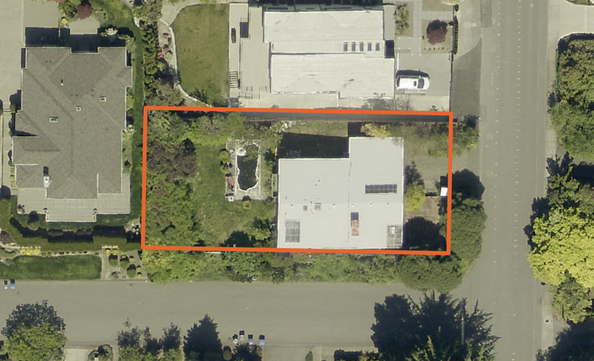
The lot sits beside two streets. Buildings, access, and visible canopy help explain why an area calculation alone is not a site plan.
Orange outline: mapped parcel. Imagery is not a survey or a current tree inventory.
King County parcel map ↗Topography and mapped constraints
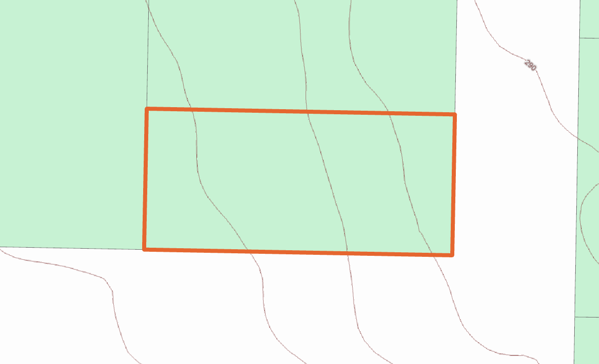
Three 5-foot contour records cross the parcel, from 275 to 285 ft. That is about 10 ft of mapped relief, not a calculated slope or a guarantee of easy grading.
Orange outline: mapped parcel. Thin contour lines: elevation. Map colors are not a critical-area clearance.
King County iMap for this parcel ↗Estimated area after base setbacks

The corner-lot model applies 30 ft along both street edges and 10 ft at the other boundaries. The approximate envelope dimensions are 113 × 30 ft, with about 3,390 sq ft inside the base setbacks. Structural coverage is still limited to 3,213 sq ft.
Green: front yards. Red: side yards. Orange interior: base setback envelope, not confirmed buildable area. The upper-building angle rule is not modeled.
Clyde Hill R-1 zoning code ↗Map data and imagery: King County. Parcel and setback overlays: Build Eastside. The dimensions describe the approximate mapped envelope after base setbacks. They are not surveyed measurements or a confirmed building footprint.
What deserves a closer look?
The lot is smaller than the base R-1 minimum
The saved lot area is 10,710 sq ft. The R-1 chapter lists a 20,000 sq ft minimum with 100 ft frontage and depth. That difference is a question to resolve, not proof the existing lot cannot be built on.
Clyde Hill R-1 zoning code ↗Easements, HOA rules, and private approval are still unknown
The assessor fields did not return an affirmative HOA clue. That does not establish an absence of CC&Rs, view covenants, private setbacks, or design review. Recorded documents were not read or interpreted.
King County recorded document search ↗No intersection was returned for the checked critical-area layers
The saved County query returned no parcel intersection for the checked floodplain, incorporated landslide, landslide-hazard, wetland, and shoreline-management layers. This does not mean all critical areas or nearby buffers are absent.
King County iMap for this parcel ↗Trees and views need a closer look
Aerial imagery shows canopy around the lot, but not reliable tree counts, species, trunk sizes, ownership, or root zones. The assessor labels Olympics and Seattle skyline views as excellent, and Lake Washington as fair. Those are valuation categories, not protected view rights.
Clyde Hill tree, view, and sunlight code ↗Public services are indicated, but capacity is unconfirmed
The assessor lists residential use, water district service, public wastewater, and public road access. It also records moderate traffic noise. These labels do not establish connection locations, service capacity, or current noise levels.
King County assessor ↗Go deeper: Clyde Hill zoning and setbacks, tree rules, and easements and HOA restrictions.
Sources and important limitations
The original property research is dated September 10, 2026. This public excerpt and map copies were prepared September 11, 2026. Source links open the providers’ current pages, which may differ from the saved study. A linked document index is not a completed title search.
A useful starting point, not confirmed feasibility
This study is based on publicly available data. It does not establish what can be permitted or built. Before relying on it, arrange the appropriate professional checks:
- A surveyor to confirm boundaries, easements, topography, and site features
- An architect to test the design, measurements, and applicable City rules
- A geotechnical engineer and arborist to evaluate ground conditions and trees
- A civil engineer to confirm drainage, utilities, access, and site improvements
- A title and HOA document review for private restrictions and approvals
- City confirmation of the applicable rules and required permits
Get a free feasibility study for your address.
Tell us what you want to build. Get a private study of the available property data, applicable rules, maps, and the next questions to resolve.